


August 20, 2021
 |
||||
|
New Resource: Interactive Map of 911 Data
|
||||
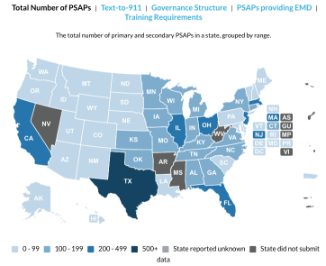
| In collaboration with state and local 911 leaders across the nation, the National 911 Program today introduced an interactive map of state-level 911 data. | ||||
 |
||||
|
The map incorporates self-reported data from states and territories across the nation, providing the most comprehensive overview of 911 system structure, call volume, staffing and progress toward NG911. These data help 911 systems benchmark progress over time, compare progress with similar systems and provide legislators, public safety leaders and the public with an interactive summary of state 911 system characteristics.
Much of the data is derived from the 911 Annual Report, though additional voluntarily submitted data is also included to provide the most complete picture of 911 across the nation.
The current version of the map displays data from the 2019 data and will be updated with 2020 data when the next annual report is released later this year.
|
||||
 |
||||